Thursday, July 28, 2011
Well I guess I'll head home
This is going to be a really short entry as I'm typing on an iPad which aren't easy to type on. But hey it's an iPad. A sign of civilization. Which I am about to depart. I've been enjoying amazing food fantastic weather and a comfy bed for the past five days in Hermosa beach, ca. I thoroughly enjoyed mt time here in southern cal and I will have more to talk about when I get to a mcdonalds and can be on my own computer. But for now, it's off to sequoia np! And this time imnot alone. For the 3000mile trip home I will be accompanied by Justine. It's going to be a very fun and excitibtrip back. After sequoia were stopping by Vegas and then the grand canyon then after that who knows! well be back east by mid august though that I can say. Heading east here we go!
Wednesday, July 20, 2011
Moving down the golden coast
After a scary ending to my last McDonalds stay, I feel much safer in the one im in now, in Morro Bay, Ca. I stayed in a campsite last night in Los Padres National Forest. Cheap place, relatively speaking. Only $12. I talked a while to the campground host at that site. He told me campgrounds used to cost $3 everywhere back in the 80's. He said he traveled across Asia for 16 months threw India, Pakistan, Afghanistan, places you could never get to as an American today. He also said that he'd been the campground host of the Bottcher's Gap campground for 20 years. Now this campground was definitely off the beaten path, 8 miles up a switchback road from the coast. It took me close to a half hour to drive it. But gorgeous site, with overviews of Los Padres National Forest from the bluff on which the site is located. But back to the campground host. He'd been at that site for 20 years. 20 years! Doing nothing but being the host of a campground, living out of his rv. For 20 years. He was a nice enough guy, but man, talk about isolation. It's probably why he loved talking to me. I did a hike today from my campsite, but upon return to my tent, I was exhausted. Probably a result of little sleep the past two nights. The past two days, Ive awoken extremely early to vacate my campsite before the campground ever knew I was there. I know its wrong not to pay, but I don't feel bad when they're charging $50/night. I'm not paying that kind of money for a spot in the dirt. I'd rather stay in a hotel. Point being, back in my tent, I passed out for almost two hours before waking in the mid afternoon and packing up my stuff.
My goal today was to make the drive down rt. 1, driving down the Big Sur. If you ever drive from San Francisco to LA or vice versa, be sure to take this coastal route. Although the hairpin turns make traveling the 70 mile portion of the road a bit slow going (took me almost 3 hours), its well worth it. Fantastic views of the rugged coast of central California, with plenty of pullouts to take pictures. I stopped only a few times, trying to make it to Morro Bay before dusk. But the few stops I made were real winners. Got some fantastic pics, and at one of my stops, I had 2 California Condors pass by me at eye level! There are to reintroduced populations of Condors. I saw one individual from the Grand Canyon population, and now I've seen two birds from the California population! It was really cool, because they were both adults and really appeared enormous flying by so close. They're much bigger than any eagle you've ever seen. At one point they passed within 20 feet of my vantage point. Unfortunately that picture didn't turn out so well. Should have just admired them instead of trying to photograph. Sometimes taking pictures takes away from the enjoyment of nature. Sometimes its just better to watch and soak it all in. Anyway, fantastic drive down the coast, sun out the whole time. Two things would have improved my trip: 1) if I was in a convertible, 2) if i had someone else to drive it with. That way one could drive while the other got to check out the scenery. Then you switch drivers halfway and everyone wins.
Made it to Morro Bay tonight. Did a short run around Morro Rock, a huge mass of shoreline rock which shoots out of the ocean and can be seen from anywhere in town. I drove into the local state park after my run and borrowed their shower services. Showers feel so good these days. Not sure if Im camping there tonight, or at a campground in the mountains. It's getting late, so Ill decide that soon.
Also, so far on this trip, I've identified 356 species of birds, and seen a number of mammals, and many lizards which I admit am not able to ID. Reptiles aren't my forte. Before this trip, 10 years of bird watching had yielded me around 320 species. In two months, I've already surpassed that. It's been a pretty successful trip in regards to birds so far. I think I can reach 400 birds by the end of this trip. Thats my goal, We'll see if it can be done.
Monday, July 18, 2011
San Francisco
Whew! What a day! And its not over...im still in a McDonalds typing about my life here. Like I said before, I was up very early to ditch the overpriced campground. Check. Then I went back to the Point Reyes Visitor center to search for some California specialty birds. Check. Found California Towhee, Oak Titmouse, White-tailed Kite, and California Quail. Then it was off to a nearby beach to do some shore birding and finally put my feet in the water. Check. Quick nap and snack food before heading out of the park? Yup. Next back to visitor center to order that part for my busted tent. Check. Ok, it's noon, time to head to San Fran. But wait, what about Muir Woods! Now we can't drive all this way and not see the towering Redwoods, can we? Course not. Detour into Muir Woods National Monument to see 275foot tall Redwoods, some of the tallest trees in the world. Check. Ok, now lets go to San Francisco. The short drive took a lot longer than planned. All roads leading to and from Muir Woods are like being on a roller coaster. The roads are literally banked to help your car through the turns. In fact most of the area is driving like this. Switchback after countless switchback, up and down hills. It seems to me like a lot of extra pavement was laid down and a lot of extra effort was put into building these roads. But I guess that's what makes California so special. Everything has to be on a grand scale, even their roadways. Alright, stepping off my soap box.
San Francisco baby! Last time I was hear, I was just a little 6th grader being held at the arm by my grandmother, as we toured along the coast, beginning in San Fran, and eventually making our way to San Diego. We were part of an elderly tour it seemed, and although we got to see all the sights on that trip, I have always wished to go back, not necessarily to see the same touristy locations, like Alcatraz or the historic missionaries that dot the coast. No, I wanted to go back to explore the wilds of California on my own time, free to come and go as I please. Enter this grand trip! Although San Francisco isn't one of the natural spectacles that I've been writing mostly about so far, it still is a great city, and I wanted to see a bit of it before heading further down the coast. I drove across the Golden Gate Bridge- completely enshrouded in fog coming off the ocean- and parked at an overlook just below the bridge (which I still couldn't even see). I ended up doing an hour long run, one of my longest of the trip, from the bridge down to Fisherman's Wharf and back. I avoided the big hills of center city, but still got a great taste for the local culture and atmosphere. Runners, wannabe runners, cyclists galore, dogs, beaches, swimmers in the shark infested bay, foggy views of Alcatraz, homeless people, the smells from bayfront restaurants, boats on the water, even some free flying parrots. This city is also known for it's gay communities, and I saw a few men holding hands too. All in all, a very cultured run, and probably one of the most scenic I've ever taken had. Afterwards, though I was beat, and as my meals havent been so healthy lately (can't remember the last time I've had meat), I decided to tour the eateries of Fisherman's Wharf. I scored big! Thanks to a tip from Mark Vorensky, a fellow IC runner who has been to the area before, I found a new fast food restaurant, the In'n'Out burger house, and feasted on a double cheeseburger and fries. Next, I went to a nearby Italian Resaurant and had a bowl of clam chowder and a Roy Rogers (coke and grenadine, hit...the...spot). I was surprised that they also provided me with a basket of bread. Of course I stashed that in my sweatshirt to eat for later. I figured I'd go for desert, so a bowl of cake batter ice cream from Cold Stone capped off a fantastic little trip, and all that food for just about $20? You bet! San Francisco, you've done well in my book. Despite your crazy road system and somewhat incompetent drivers (I had to show some anger towards some guy parked in a "NO PARKING" zone), I still love you. Who knows, maybe I'll stop back in tomorrow. Eh, we'll see. I have plans to head down the Big Sur. If I do that, I won't be back online for a few days, and if that's the case, I may only have one more post before getting to LA! There's a lot of homeless people gathering around this McDonald's. One guy keeps coming in and plugging his phone into the outlet over and over. He said hi to me, and I said hi back. They all seem friendly enough. But I don't want to spend too much more time in this McDonald's. It's almost 11, and I'm sitting here with an expensive camera and laptop. Im not trying to jump to any conclusions, but you'd be a little nervous too.
Some guy just tried to fist pump me.....I think I'm going to head out.
Some guy just chucked a die at some other guy....yup definitely time to go. Again sorry for the lack of pics lately. Please check back in either a few days for some. If not then, I will definitely have time to update it this weekend when I get to LA and have time to relax.
 |
| Is he still out there? |
 |
| Clouds rolling in north of San Francisco |
 |
| Redwoods in John Muir NM |


 |
| Fog on the Golden Gate. Photo taken while driving |
 |
| Learning how to swim |
 |
| feeding the pigeons, a must-do in order to really experience any city |
coast to coast
Well, I made it! On Sunday, the 17th of July, I finally saw the Pacific Ocean! Oh what a fantastic sight! I havent seen the ocean in a few years, not even the Atlantic. Im not much of beach bum, so I don't travel to the Jersey shore very often. But man, was I happy to finally see that coast. It first showed itself as I drove through Oakland, looking across the San Francisco Bay to the Golden Gate Bridge, the gateway to the ocean. It was even more revealing when I entered Point Reyes National Seashore, MUCH more revealing. This park was given federal designation under JFK and protects hundreds of miles of rocky coast with intermittent sandy beaches. It also lies directly on the San Andreas Fault line, the point of clashing plates which were responsible for the 1989 World Series quake as well as the Great Fire of San Francisco. Getting out of my car near the point itself, I felt like a kid in a candy shop, giddy with the potential for new birds, sea faring birds I would never dream of finding anywhere else on my trip. I found quite a few, almost 10 new species for me in just a few hours at the tip of Point Reyes. I picked a perfect weather day to be out there too. Water's were calm and the sun was shining. I couldnt have asked for a better welcoming to the Pacific coast. After spending most of the late afternoon out at the point, I drove back towards mainland, and found myself the only designated campground that is near the park entrance. Being such a select campground, of course they were charging absurd prices for tent camping. $44 for a spot in the dirt. Sure they also provided laundry service, electricity, a post office, and probably showers, but I didnt need any of that. I picked out a spot, awoke at 530 the next morning and busted outa there before anyone knew I was ever there. I did put $10 in an envelope and slipped it under the office door, a fair tip for what they provided for me: a spot in the dirt.
 |
| Windmills everywhere on the way to Oakland |
 |
| Point Reyes National Seashore |
 |
| Perfect day to arrive at the pacific |
 |
| Western Gull. Theyre everywhere out here, but I'd never seen one before this trip |
 |
| Sunrise in Point Reyes |
 |
| Seashore |
 |
| Harbor Seals! |
 |
| View from the point looking landward. |
Sunday, July 17, 2011
Yosemite National Park
I think I finally found a place that rivals the spectacle that I witnessed in Banff. Yosemite National Park is massive in every way possible. I spent two days in the park. The first day was spent completely in Yosemite Valley, the place where everyone goes to take pictures of El Capitan, Yosemite Falls (the highest falls in North America), and Half Dome. I arrived in this part of the park early on Friday morning after pitching my tent on the side of the highway just outside the park in Staniclaus National Forest. The previous night, I spent driving through the entire park, from its western entrance at Tioga Pass, east though the high mountain passes, all the way to the lower, more heavily forested eastern side, without finding an open camp site! The entire park was booked solid. I had no choice but to throw up my tent in the woods outside the park. It was kind of scary at first, but it's legal, and free! Ok, back to Yosemite Valley....so Im down in the Valley at 730am, before the crowds arrive, hiking amongst giant old growth douglas firs and sugar pines that are easily 200 ft tall and over 5 feet in diameter. And watching over me the entire time was the towering colossal rock known as El Capitan, which skies to over 3000ft above the valley floor on it's north side. The hike was great though, with Pacific-coast Flycatcher and White-headed Woodpeckers new birds for me. At the halfway point, I came upon Bridalveil Falls, one of the known nesting locations for Black Swifts, a rarely seen bird that only nests behind waterfalls, and can usually only be found at dawn or dusk when it's flying to or from its nest site. I decided I'd go back to the falls at dawn to look for them. In the meantime, I hiked back to my car, went to a nearby picnic area, and boiled a pot of water so that I could cook about 3 lbs of pasta. Sorry mom, but my eating has not been the best. Mostly gas station food, with occasional produce. Pasta was the best thing I ate today, and I ate it all. It was a good thing, though, because ahead of me lay a 5 mile out, 5 mile back hike up and out of the valley to Glacier Point, which affords the onlooker unparalleled views of Yosemite Falls, Half Dome, and all the surrounding mountains. But its a hell of a climb. Over 3000ft elevation climb. I was wearing a long sleeve and jeans. Not the smartest decision, but Im trying to keep the sun off me for a little. I was huffing and puffing on the way up, wishing I was those people passing me going downhill all cheerful the other way past me. But the hike was completely worth it. Although crowded at the top (you can also drive to Glacier Point, which is what most people do), the views surpassed my expectations. The grandeur of the area was almost sickening. I housed down a few ice cream bars, a bag of cheetos and a root beer, then napped for a half hour on a rock overlooking the valley. People were walking around me, but I could have cared less. I was tired, and I was in a beautiful place. Nobody was going to bother me at this point.
Eventually, I knew I had to hike back down before it got dark. The hike down still took almost 2 hours, but it was easier than going up, as long as you dont mind the pounding on your knees....more to come... computer is about to die!
Hey, sorry for the delay! McDonald's provides internet but no outlets. Anyway, after my hike down, I headed over to Bridaveil Falls, about a mile away to watch Black Swifts come into their roost for the night. These small birds are extremely elusive and hard to find. Funny enough, they are very selective at choosing a nest location. They only live behind waterfalls. During the day, they fly 1000s of feet in the air eating insects, so the only time you can catch a glimpse of one is at dawn or dusk when they come back to their nests for the night. I climbed hand and foot over some boulders onto a small ledge where I was able to watch a few enter the backside of the waterfall before it got too dark, at which point, I got back in my car and drove back to my roadside campsite for a second night.
Day 2 found me poking around the eastern part of the park, completely avoiding the Valley, where all the tourists would be flocking to on a beautiful weekend like this. But my time was well spent. Today I viewed the other famous massive landmark of Yosemite: the Sequoia. Sequoia's are the 2nd tallest tree in the world and the 2nd oldest, to the Redwood and Bristlecone Pine, respectively (both also found in Ca). But in terms of overall size, they are the largest living things on earth. And its easy to believe. Yosemite has a few groves of these behemoths, and the one I visited had about 7 living trees, all of which were quite humbling to stand beneath. I don't lie when I say that one of the trees had a trunk diameter of close to 20 feet. Another dead tree had a tunnel carved through it which automobiles used to drive through back in the day. All the trees had to be at least 200 feet high. Why Sequoias grow so large, I have absolutely no clue, but even when surrounded by an old growth forest of Douglas Firs and Sugar Pines that have trunks of 6 or 7 feet in diameter- respectable no doubt- the sequoias tower over all.
I was pretty tired after gawking at Sequoias, combined with yesterdays hike, so I rested for a bit in my car, did a bit more hiking, went for a run, and then spent the waning hours of light hiking through a nearby meadow where Great Gray Owls are sometimes spotted. I'd already missed this bird once in Canada at a staked out location. But despite my best mouse squealing impressions (anyone can do a mouse squeal; just lick the front of your hand and kiss it. It gets kind of slobbery but it sounds like an injured animal, which attracts predators), I could not coax an owl out of the forest. It was pretty dark by the time I decided to head out, and I still had to walk back through the woods. Im not usually scared of the dark, but the woods get me every time. Thoughts of Blair Witch Project and other horrors of the like creep into my head. I just sang to myself and focused on getting to my car asap. All was fine, and my third night at my roadside tent site went off without a hitch. Except the fact that my entryway zipper no longer zips. It's only closed 3/4 of the way. To keep out the cold, I have to use duct tape on the rest of the opening to seal myself in. Plans to get that fixed are to come.
 |
| Typical Yosemite NP topography |
 |
| There was a controlled burn going along the road going into the park. Made for great photo opps in the morning light |
 |
| El Capitan and the crowds |
 |
| Yosemite Falls in the distance |
 |
| View of Yosemite Valley from near the valley floor |
 |
| Same valley 3000 ft higher |
 |
| View from Glacier Point. Half Dome on the right side |
 |
| out for a stroll? |
 |
| A Giant Sequoia |
 |
| The Tunnel Tree. dead but still cool |
 |
| A very large tree (sequoia tree) |
 |
| Grounds squirrel nomming. |
 |
| Ive taken a lot of pictures of flowers, but these were some of the most stunning i've seen |
Thursday, July 14, 2011
Desiring Social Interaction
Up until this point, the amazing birds and scenery have been enough to mask the fact that I have been doing this whole trip basically solo, with few people to communicate with. My best companion is myself, and it gets old having nobody to talk with except him after a while. But I am starting to feel a rush to get to the West coast, to see familiar faces, to have someone else to talk to. Maybe it’s just because I am so close to Hermosa Beach, my final destination where I will get to relax with Justine and her family for a few days in the Los Angeles area. I think it’s a combination of things. Honestly, I’m amazed that I have made it this far in one piece. A road trip like this, all alone, with the risks that come with backcountry hiking and driving down roads travelled by few people, I really am blessed that I’ve successfully made it this far. Sure, there have been a few blemishes so far, but nothing major. That being said, I just want to get to LA safely. There’s still a lot of cool things to see over this final week before I meet up with Justine. I’m going to try to enjoy it all to its fullest. But point is, I really cannot wait to make it to Hermosa Beach. Right now, I’m only 5 hours from LA, but I’m taking the long way there. For now, its off to Yosemite National Park for a night or two before I hit up the San Francisco area, driving south after that.
Sierra Camping (Tuesday-Thursday)
As I exited Death Valley, I began to pass a bunch of runners with bib numbers on. They were obviously part of some insane race. I stopped and asked a man who was following one of the runners in his car what kind of race this was. He told me the competitors were part of a 135 mile race going from Badwater Basin, the lowest point in the US, to the portal to Mount Whitney, the highest point in the continental US. I’d once been a part of one of these extreme races back in Ithaca, as I handed out food and water at a checkpoint to the runners who had been on the trail for over 24 hours. But that was only a 100 mile race during the fall. This was a 135 mile race! In the middle of the summer in the hottest place in the country! Each runner had a car leading the way, providing water, food, and any other needed aid. In addition each runner had rabbits which would take shifts to run with the athlete, motivating them, pacing them, making sure they weren’t about to pass out. Most of the athletes had already been running for over 24 hours, and still had quite a ways to go. I continued passing runners for over an hour along the main road out of Death Valley. How epic would it be to be a part of something like this? Run from the lowest to highest points in the US? Maybe I could do something like this, I thought to myself. Then I saw a girl passed out, probably the victim of heat exhaustion, being tended to by her team. I was already sweating myself, and I was in my car with the AC on. What a bunch of nuts.
 |
| Some of the crazy runners in the desert. |
I eventually made it my destination the Sierra Nevadas. I purchased a 2-night backcountry camping permit, and hit the trail into the mountains. I had to make sure that I brought with me all the essentials and nothing extra. I packed just enough food for two days in the wilderness, my tent, and a few other things. Then hit the trail, hiking into the mountains about 2.5 miles before having to pitch my tent as darkness quickly approached. I’m obviously a novice at this whole backcountry camping thing, as I forgot a few things. First off, I couldn’t fit my sleeping back in my pack, so I decided to bring my fleece blanket instead, thinking that would keep me warm enough. I forgot, however, to take into consideration the drop in temperature as I climbed in altitude to about 10,000 feet to camp. The patches of snow should have been a clue to the cooler temperatures in the mountains. Setting up my tent, I was chilly. I had already removed my tshirt, which was wet from sweat on the hike up. No worries, just let me grab the long sleeve that I packed…..yea, I forgot to pack that too. So it’s like 40 degrees, all have for warmth is a windbreaker a fleece blanket. Again, another restless night of sleep ensued, this time because I was too cold. I awoke in the morning with freezing feet. Had to rub them out for 5 minutes to get the blood flowing again, work out the cramps.
I did have a wonderful day in the mountains once I got into the warmth of the sun. I did a 9 mile hike up over the Keargass pass and into Kings Canyon National Park. Spectacular views of 13,000 foot peaks, alpine lakes and meadows, and lots of boulder hopping. But another rookie mistake, I hadn’t planned on hiking such a long and strenuous hike when I started out, leaving behind all my water, packing only an orange and some pretzels. 6 hours later, I made it back to base camp, housed the rest of my food and water. Completely drained, I napped.
It was almost 5 when I decided to head out of the mountains. I still had one more night worth of backcountry camping to use. But with the cold weather coming and my food supplies exhausted, I didn’t really have a choice. I spent the night at a campground just outside of the town of Independence, where the sleeping temps were much more accommodating. With a full moon lighting up my camp site, I took a quick sponge bath (I hadn’t showered since before visiting Death Valley) before falling fast asleep under the stars.
 |
| Mt. Whitney, highest point in the continental US |
 |
| After a cold night's sleep, at least I had this to wake up to |
 |
| View of Kings Canyon National Park from Keargass Pass |

 |
| One of the big Jeffrey Pines in Kings Canyon |
 |
| Dehydrated, tired and hungry, atop Keargass Pass. |
Death Valley National Park (Monday-Tuesday)
I made the drive from Las Vegas to Death Valley National Park on Monday evening. The park itself isn’t too far from the strip, maybe only 2 hours, so I only made one stop at a gas station/convenience store off the highway before the last turn to the park entrance. But what a stop, this gas station was nearly empty of conveniences. Most of the shelves were bare. But what it lacked in food and water, it made up for in alien apparel. Turns out this spot is about as close as you can get to the high security Nevada military base which holds Area 51. For those who haven’t heard, Area 51 is supposed to be this place where the government has captured and is performing studies on aliens. Nobody is allowed into the area, so whats really there remains a mystery. But this gas station certainly believes that the aliens exist. All sorts of alien shirts, posters, bumper stickers were for sale. They even had a photo booth to get your picture taken with an alien (not sure how that worked). To add to the creepiness of the place, the back of the convenient store was a “historic” brothel museum and a small 24 hour strip joint. I left with my gas and headed out before it was too dark.
 |
| Shady strip joint probably being enjoyed by the two truckers in the parking lot |
As I made my way to Death Valley, the outside temperature kept increasing, even though the sun was getting lower on the horizon. The drop in elevation from 2000 ft to below sea level explained this weird phenomenon. By the time I arrived at my campsite at the bottom of the valley, it was 10 at night and 102°. I went to bed on the picnic table provided for me at around 11 and it was still over 100 out. My first night’s sleep in California was probably one of my worst of the trip, and not because of the heat. I awoke on my picnic table at 2am to a strong breeze of hot air, and it kept me up. I wasn’t about to sleep on the ground, lest I be attacked by some poisonous critters. My only choice was to set up the tent. I figured I could do that in 20 min and be back asleep real soon. Wrong. The dark alone extended the setup time. Then the tent’s entryway zipper decided to cease zippering. With only 3/4 of the door flap closed, I had to duct tape the rest of it shut. Then the continuing wind kept lapping the sides of the tent, which kept me up. My attempt to throw clothes up against the edge of the tent to make the fabric taught and stop the noise was only semi-successful. I eventually fell asleep out of frustration with the whole situation.
The next morning was a bit better, but still hot. Up at 6:30, I packed my stuff up, and drove down to Badwater Basin, site of the lowest point in the country at -260 ft below sea level. Its all salt flats which have been deposited there over thousands of years after being carried there from ground water. By 8, it was already back into the high 90’s and the sun was bearing down on me. I drove back to the main hub of the park, the Furnace Creek Ranch. Not sure where the ranch get’s there water, but they’ve created their own little oasis, with the only green space in the entire valley. It’s the only place for miles that has trees. Somehow they’ve been able to maintain a fairly green 18 hole golf course, as well as lodging, tennis courts, a swimming pool, a general store and bar/grille. Pretty neat place, where people from all over seemed to gather, like animals at a watering hole. Everyone was speaking foreign languages too. Who knew such an inhospitable place would bring tourists from so far off. I hiked around here for an hour, doing some bird watching. Not many birds in these parts, but the only birds that I did find were around the ranch. At around 11, I decided to head out. I hadn’t quite stayed long enough to witness the 115 degree temps expected for the heat of the day, but I didn’t care. I’d had enough of the heat, and desired the cooler temps of the Sierras just 100 miles away.
 |
| Badwater Basin, Death Valley National Park |
 |
| The only water in Death Valley is extremely salty. This is where the name Badwater basin came from. |
 |
| -260 ft |
 |
| This is what you can do when you own the only gas for 100 miles |
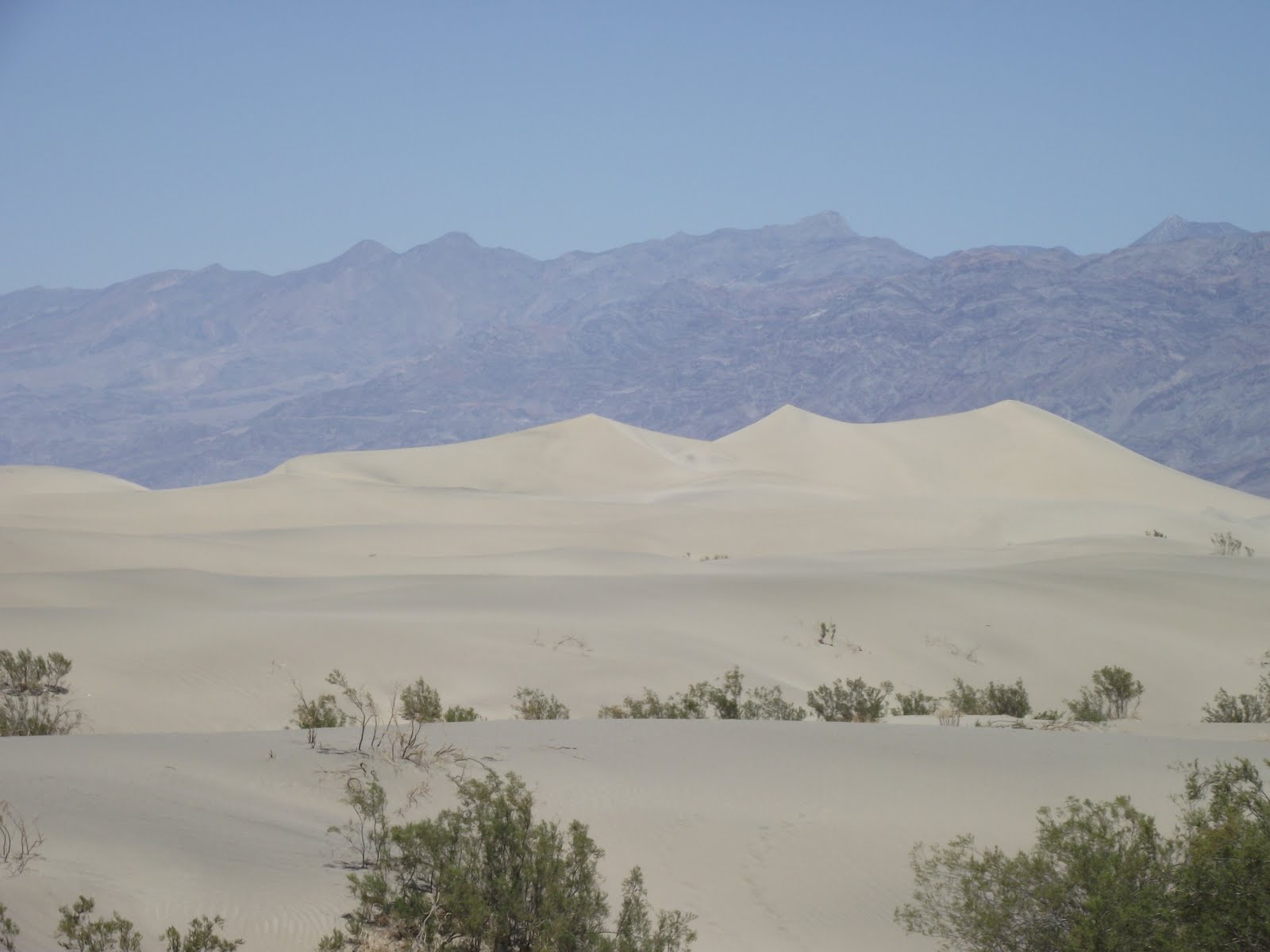 |
| Sand dunes heading out of Death Valley |
Subscribe to:
Comments (Atom)